

Archive Record
Images
Metadata
Title |
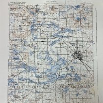
State of Michigan Represented by the Department of Conservation Geological Survey Division |
Object Name |
Map |
Scope & Content |
A reprinted 1907 map showing West Bloomfield and other Oakland County townships and cities by the Department of the Interior U.S. Geological Survey. H.M. Wilson, Geographer. Frank Sutton, in charge of section. Topography by A.M. Walker and C.H. Birdseye. Control by George T. Hawkins and J.M. Whitman. Surveyed in 1905-1906. Surveyed in cooperation with the State of Michigan. |
Date |
1907 |
Subjects |
Maps Cities & towns Lakes & ponds |
Collection |
Aerials, Maps |
Catalog Number |
2025.3.1 |
Search Terms |
West Bloomfield Maps |